


Taylor Voting District, Sullivan County, Missouri
About
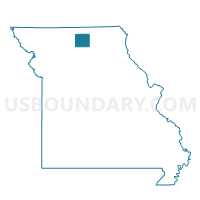
Outline

Summary
| Unique Area Identifier | 611446 |
| Name | Taylor Voting District |
| County | Sullivan County |
| State | Missouri |
| Area (square miles) | 36.23 |
| Land Area (square miles) | 36.02 |
| Water Area (square miles) | 0.22 |
| % of Land Area | 99.40 |
| % of Water Area | 0.60 |
| Latitude of the Internal Point | 40.06614330 |
| Longtitude of the Internal Point | -93.30064180 |
Maps


Graphs
Select a template below for downloading or customizing gragh for Taylor Voting District, Sullivan County, Missouri


Neighbors
Neighoring Voting District (by Name) Neighboring Voting District on the Map
- Browning Voting District, Sullivan County, MO
- Humphreys Voting District, Sullivan County, MO
- Jackson Voting District, Linn County, MO
- Liberty Voting District, Grundy County, MO
- Marion Voting District, Grundy County, MO
- Reger Voting District, Sullivan County, MO
- Wilson Voting District, Grundy County, MO
Top 10 Neighboring County Subdivision (by Population) Neighboring County Subdivision on the Map
- Liberty township, Grundy County, MO (436)
- Wilson township, Grundy County, MO (406)
- Bowman township, Sullivan County, MO (395)
- Duncan township, Sullivan County, MO (385)
- Marion township, Grundy County, MO (248)
- Jackson township, Linn County, MO (173)
- Taylor township, Sullivan County, MO (98)
Top 10 Neighboring Place (by Population) Neighboring Place on the Map
Top 10 Neighboring Elementary School District (by Population) Neighboring Elementary School District on the Map
Top 10 Neighboring Unified School District (by Population) Neighboring Unified School District on the Map
- Milan C-2 School District, MO (3,958)
- Linn County R-I School District, MO (1,580)
- Meadville R-IV School District, MO (1,279)
- Grundy County R-V School District, MO (1,040)
Top 10 Neighboring State Legislative District Lower Chamber (by Population) Neighboring State Legislative District Lower Chamber on the Map
Top 10 Neighboring State Legislative District Upper Chamber (by Population) Neighboring State Legislative District Upper Chamber on the Map
Top 10 Neighboring 111th Congressional District (by Population) Neighboring 111th Congressional District on the Map
Top 10 Neighboring Census Tract (by Population) Neighboring Census Tract on the Map
- Census Tract 4902, Linn County, MO (2,300)
- Census Tract 9601, Grundy County, MO (2,124)
- Census Tract 4802, Sullivan County, MO (1,579)